 |
|
|
Las Vegas: An Unconventional History |
Maps |
| http://www.pbs.org/wgbh/amex/lasvegas/maps/maps_text_00.html | |
 The Nevada territory was virtually unexplored by Americans and Europeans until Spanish merchants established trading routes from Sante Fe to Los Angeles in 1829. They dubbed a marshy area along the way Las Vegas -- "the meadows." |
|
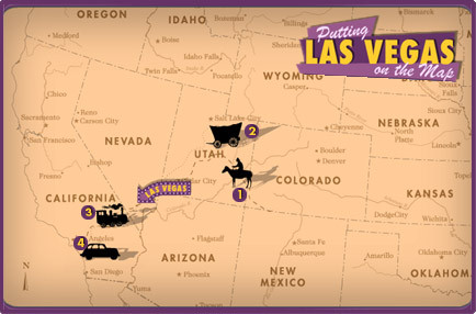 As explorers and settlers moved westward throughout the American continent, Utah and California became influential neighbors to the Nevada territory. From dusty mule trails, to iron rails, to hot asphalt -- new routes have been surveyed, graded, and paved in order to pass goods and people between California and inner territories. Las Vegas blossomed as a key stopping point on the route, benefiting from three key things: location, location, location.
2 Mormon expedition and settlement (1855)
The Mormons built a 150 square foot adobe fort and established relations with the local Paiutes. But after three difficult years, Brigham Young ordered the Mormons to abandon the settlement and return to Utah. 3 San Pedro, Los Angeles & Salt Lake Railroad (1905)
|
|

The 1920s were a time of prosperity for most of America. Though the population of the city of Las Vegas more than doubled throughout the decade. It was still a small town -- slightly over 5,000 residents in 1930 -- surrounded by vast undeveloped land. Over the next two decades, several large scale federal projects began exploiting the resources and remote location, literally remaking the greater Las Vegas area. A city that gained national notoriety for turning away from Prohibition became a key national player in the American effort in World War II and the Cold War. 1 Boulder Dam (1931-1935) As early as 1902, when President Theodore Roosevelt signed the Reclamation Act, government engineers began exploring the idea of controlling the wild Colorado River. On December 21, 1928, outgoing President Calvin Coolidge signed the Boulder Canyon Project Act, to construct a massive dam 25 miles outside of the small town of Las Vegas. President Franklin D. Roosevelt dedicates the Boulder Dam, a massive engineering feat, in 1935. The dam was renamed the Hoover Dam in honor of President Herbert Hoover on April 30, 1947. Six Companies, Inc., the collection of constructing companies behind the Boulder Dam, built a complete city to house dam workers, complete with a hospital, department store, homes for married couples, and dormitories for single men. Sims Ely, the city manager, made sure that the city was all about business, and some residents soon made the trek up to Vegas on payday to escape sleepy Boulder City. 3 Army Air Corps Gunnery School (early 1940s) In 1941 the U.S. Army established the Army Air Corps Gunnery School at the site of an old airport north of Las Vegas. After the attack on Pearl Harbor in December, and the U.S. entry into World War II, the school became a critical part of the American War effort, training over fifty-five thousand gunners over the next four years. The school closed in 1949, and was reopened as the Nellis Air Force base in 1950, named after William Nellis, a Las Vegas High School graduate shot down over Belgium in 1944. 4 Basic Magnesium, Inc. / Henderson (1942) Magnesium was a key "wonder metal" in the World War II effort, used for airplanes and bombs. Nevada Senator Pat McCarran helped convince President Roosevelt that southern Nevada was ideal for magnesium processing. It was a convincing argument; there were raw magnesium ore deposits in the area, the Boulder Dam could provide the power for the factory, and the newly formed Lake Mead could provide water to cool the hot processed magnesium ingots. The U.S. government contracted Basic Magnesium, Inc. to build the biggest magnesium processing plant in the world -- almost two miles long by 3/4 miles wide. The plant employed 10% of Nevada's population, more than twice the number of employees than the Boulder Dam had at its peak. BMI's "version" of Boulder City was the city of Henderson. Henderson's presence increased the already steady traffic along the Las Vegas and Boulder City route. The plant closed in 1944 when the government determined it needed no more magnesium. Perhaps the biggest legacy of BMI is the federally funded waterway that brought water from Lake Mead into the Las Vegas Valley and served as the basis for the Las Vegas Valley Water District. 5 Nevada Proving Ground (early 1950s) Government interest in the Las Vegas area evolved after World War II to address the Communist threat. The Defense Department and the Atomic Energy Commission (AEC) wanted to find a nuclear test area closer than the ones being conducted in the Bikini Atoll in the Far Pacific. With persistent lobbying again from Nevada Senator Pat McCarran, President Truman and the AEC selected an area used as a bombing range by the Nellis Air Force base. The AEC detonated the first bomb at the Nevada Proving Grounds in January 1951. The site of mushroom clouds on the horizon -- not a threat to safety, according to AEC scientists -- afforded Las Vegas a new "atomic" identity .
|
|
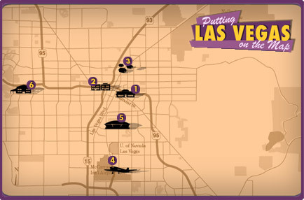 The City of Las Vegas has continually redefined itself as a means to attract visitors: western prospectors, dam laborers, vice tourists, conventioneers, and family tourists. Beyond the ebb and flow of tourists, Las Vegas' population has changed in demographics and make-up: from old Western prospectors, to Los Angeles organized crime players, to Boulder Dam laborers, to nuclear engineers, and tourism workers. The jobs to support the growing city -- teachers, municipal workers, construction workers and real estate agents -- boosted the population further. 1 Fremont Street (1905)
4 McCarran Airport (1948,1963)
5 Las Vegas Convention Center (1959)
6 Summerlin neighborhood (1990s)
|
|
 Throughout the 1940s, beginning with the El Rancho Vegas casino, casino owners, many transplanted from Los Angeles, built up the area to the south of Las Vegas on Highway 91 -- just outside the official city limits to avoid taxes, and also to be the first to attract drivers from L.A. Guy McAfee, proprietor of the 91 Club and the Golden Nugget, remarked that it reminded him of the famous Sunset Strip in Los Angeles and the "Las Vegas Strip" became an iconic stretch of roadway. The resorts featured inviting swimming pools, glamorous style and distinctive architecture to attract traffic from Los Angeles. No area of Las Vegas morphs more regularly than this stretch of road. From the original western themed casinos of the 1940s to the swinging palaces of the 1960s to the virtual cities of the 21st century -- the Strip is what most people think of as Las Vegas. The popularity of the Strip shifted the entertainment center from the Fremont Street area downtown, to this four mile stretch. 1 El Rancho Vegas (1941)
2 "Welcome to Fabulous Las Vegas, Nevada" Sign (1959)
5 The Las Vegas Monorail (2004)
6 The Little Church of the West (1942)
|
|
") In the winter of 1829, New Mexican traders moved through Nevada on mule
trails, carving out the Old Spanish Trail to Southern California. They
stopped at a valley of marshy plains and meadows, encountering nomadic
Paiute tribes who also sought out the lush environs.
In the winter of 1829, New Mexican traders moved through Nevada on mule
trails, carving out the Old Spanish Trail to Southern California. They
stopped at a valley of marshy plains and meadows, encountering nomadic
Paiute tribes who also sought out the lush environs.") William Bringhurst led thirty Mormons from Salt Lake City to Las Vegas
in 1855 to establish a mission between Utah and San Bernardino,
California, which the Mormons had settled in 1851. Like the Spanish
traders before them, they chose the spot along the Old Spanish Trail and
followed a route mapped out by Captain John C. Fremont of the U.S. Army
Topographical Corps.
William Bringhurst led thirty Mormons from Salt Lake City to Las Vegas
in 1855 to establish a mission between Utah and San Bernardino,
California, which the Mormons had settled in 1851. Like the Spanish
traders before them, they chose the spot along the Old Spanish Trail and
followed a route mapped out by Captain John C. Fremont of the U.S. Army
Topographical Corps.") On August 21, 1900, officials of the Los Angeles Terminal Railway
announced that Montana mining magnate
On August 21, 1900, officials of the Los Angeles Terminal Railway
announced that Montana mining magnate ") In 1929 California approved financing of $800,000 to pave the Los
Angeles Highway (Highway 91) from San Bernardino to the Nevada state
line, in order to provide easier access to Las Vegas and the
In 1929 California approved financing of $800,000 to pave the Los
Angeles Highway (Highway 91) from San Bernardino to the Nevada state
line, in order to provide easier access to Las Vegas and the ") Senator
William Clark and associates set up the Las Vegas Land & Water
Company to manage their new city at the railroad depot. On May 15, 1905,
they operated an auction from a platform on Main Street, between Fremont
and Ogden streets. By the end of May 16, about half of the lots had been
sold for a total of $265,000. The railroad built a depot at Main and
Fremont Street. Clark and associates decided that Fremont Street would
be the major commercial avenue in the nascent city.
Senator
William Clark and associates set up the Las Vegas Land & Water
Company to manage their new city at the railroad depot. On May 15, 1905,
they operated an auction from a platform on Main Street, between Fremont
and Ogden streets. By the end of May 16, about half of the lots had been
sold for a total of $265,000. The railroad built a depot at Main and
Fremont Street. Clark and associates decided that Fremont Street would
be the major commercial avenue in the nascent city.") John T. McWilliams was a Canadian born civil engineer that worked for
the Union Pacific and William Clark. McWilliams bought eighty acres of
land from Helen Stewart and set out to establish the "Original Las
Vegas Townsite" on the western side of the tracks. The McWilliams
Townsite was home to fifteen hundred residents and had three weekly
newspapers. But Clark controlled the water rights to Stewart's ranch
land. On September 5, 1905 a fire all but destroyed McWilliams Townsite.
John T. McWilliams was a Canadian born civil engineer that worked for
the Union Pacific and William Clark. McWilliams bought eighty acres of
land from Helen Stewart and set out to establish the "Original Las
Vegas Townsite" on the western side of the tracks. The McWilliams
Townsite was home to fifteen hundred residents and had three weekly
newspapers. But Clark controlled the water rights to Stewart's ranch
land. On September 5, 1905 a fire all but destroyed McWilliams Townsite.") The Westside neighborhood of Las Vegas stands where McWilliams Township
did, on the west side of the tracks. The neighborhood lagged behind the
city on the other side of the tracks and by the 1940s, town officials
began to segregate
The Westside neighborhood of Las Vegas stands where McWilliams Township
did, on the west side of the tracks. The neighborhood lagged behind the
city on the other side of the tracks and by the 1940s, town officials
began to segregate ") McCarran Airport opened in 1948 as the Clark County Public airport, on
the grounds of what had been the Alamo Airport. Within ten years, Las
Vegas officials feared that McCarran might become obsolete with the
advent of the jet age, but they also were unsure if residents would
approve a new bond to "rebuild" the airport. The business
community pledged their support to an expanded airport and voters
approved the bond issue in 1960. The new airport opened in 1963, and
five years later was officially renamed McCarran International Airport.
McCarran Airport opened in 1948 as the Clark County Public airport, on
the grounds of what had been the Alamo Airport. Within ten years, Las
Vegas officials feared that McCarran might become obsolete with the
advent of the jet age, but they also were unsure if residents would
approve a new bond to "rebuild" the airport. The business
community pledged their support to an expanded airport and voters
approved the bond issue in 1960. The new airport opened in 1963, and
five years later was officially renamed McCarran International Airport.") In the 1950s, on the heels of the new McCarran airport opening, city
officials and casino operators looked to bring a new wave of visitors to
Las Vegas: the conventioneer. A convention during the week would
supplement the weekend visitors from L.A. and give hotels and casinos
steady traffic, seven days a week. In 1955 the Nevada State Legislature
approved the huge convention center, financed by room taxes in hotels,
so that residents wouldn't feel the pinch. In April 1959 the Las Vegas
Convention Center opened with a 90,000 square foot exhibit hall and
20,340 square-foot rotunda.
In the 1950s, on the heels of the new McCarran airport opening, city
officials and casino operators looked to bring a new wave of visitors to
Las Vegas: the conventioneer. A convention during the week would
supplement the weekend visitors from L.A. and give hotels and casinos
steady traffic, seven days a week. In 1955 the Nevada State Legislature
approved the huge convention center, financed by room taxes in hotels,
so that residents wouldn't feel the pinch. In April 1959 the Las Vegas
Convention Center opened with a 90,000 square foot exhibit hall and
20,340 square-foot rotunda.") Las Vegas had typically expanded its suburban development eastward from
downtown and the Strip, eventually spreading out towards Henderson. In
the 1980s, new planned communities began emerging west of the strip.
Many of these communities were too far out to be annexed by the City of
Las Vegas and existed as unincorporated towns. The city developed on an
area of land owned by the Howard Hughes Corporation as a new community
named Summerlin. The corporation allowed Las Vegas to annex the land in
order to access its sewage treatment plants, which made development and
home owning more affordable. Since the 1990s, the beautified community
has grown at a quick pace, with over 3,500 residents by 2000.
Las Vegas had typically expanded its suburban development eastward from
downtown and the Strip, eventually spreading out towards Henderson. In
the 1980s, new planned communities began emerging west of the strip.
Many of these communities were too far out to be annexed by the City of
Las Vegas and existed as unincorporated towns. The city developed on an
area of land owned by the Howard Hughes Corporation as a new community
named Summerlin. The corporation allowed Las Vegas to annex the land in
order to access its sewage treatment plants, which made development and
home owning more affordable. Since the 1990s, the beautified community
has grown at a quick pace, with over 3,500 residents by 2000.") In 1940 city officials began coaxing Californian hotel mogul Thomas Hull
to build one of his successful El Rancho hotels in Las Vegas,
recommending spots near Fremont Street. Hull surprised them by
purchasing a massive tract of land south of the city on the Los Angeles
Highway. By being officially outside of the city, Hull was able to avoid
certain city taxes. The El Rancho Vegas, a huge, sprawling resort,
opened in 1941 and was soon joined by other opulent resorts including
the Last Frontier, Flamingo and Thunderbird.
In 1940 city officials began coaxing Californian hotel mogul Thomas Hull
to build one of his successful El Rancho hotels in Las Vegas,
recommending spots near Fremont Street. Hull surprised them by
purchasing a massive tract of land south of the city on the Los Angeles
Highway. By being officially outside of the city, Hull was able to avoid
certain city taxes. The El Rancho Vegas, a huge, sprawling resort,
opened in 1941 and was soon joined by other opulent resorts including
the Last Frontier, Flamingo and Thunderbird.") In 1959
In 1959 ") Despite efforts by Las Vegas City to bolster the downtown area with new
hotels, the Strip continued to steal the limelight -- and the traffic.
Jay Sarno of the Cabana Motel chain wanted to make a statement with an
over-the-top resort. Sarno showed no restraint in building Caesars
Palace -- importing tons of marble, statues and other adornments. The
opulent rooms were complemented with top-level international cuisine and
A-list entertainers.
Despite efforts by Las Vegas City to bolster the downtown area with new
hotels, the Strip continued to steal the limelight -- and the traffic.
Jay Sarno of the Cabana Motel chain wanted to make a statement with an
over-the-top resort. Sarno showed no restraint in building Caesars
Palace -- importing tons of marble, statues and other adornments. The
opulent rooms were complemented with top-level international cuisine and
A-list entertainers.") By the 1980s the Strip had lost much of its luster and prominence.
Atlantic City, New Jersey gambling had lured East Coast visitors away
from making the cross-country trip to Nevada and deadly hotel fires
further eroded Las Vegas' charm. Steve Wynn, who had revived The Golden
Nugget in downtown Las Vegas, set out to raise the bar on the Strip, as
Jay Sarno and Thomas Hull had done decades earlier. In 1989 Wynn opened
the Mirage -- a true mega-resort in scale -- and an outlandish
entertainment experience complete with working volcano, dolphins and
white tigers. Wynn's follow-ups (including Treasure Island, the Bellagio
and Wynn-Las Vegas) found competition in mega-resorts like New York-New
York, the Luxor and the Venetian. The Las Vegas Strip was once again
unlike any other place in the world.
By the 1980s the Strip had lost much of its luster and prominence.
Atlantic City, New Jersey gambling had lured East Coast visitors away
from making the cross-country trip to Nevada and deadly hotel fires
further eroded Las Vegas' charm. Steve Wynn, who had revived The Golden
Nugget in downtown Las Vegas, set out to raise the bar on the Strip, as
Jay Sarno and Thomas Hull had done decades earlier. In 1989 Wynn opened
the Mirage -- a true mega-resort in scale -- and an outlandish
entertainment experience complete with working volcano, dolphins and
white tigers. Wynn's follow-ups (including Treasure Island, the Bellagio
and Wynn-Las Vegas) found competition in mega-resorts like New York-New
York, the Luxor and the Venetian. The Las Vegas Strip was once again
unlike any other place in the world.") In 2004, the Las Vegas Monorail Company, a non-profit corporation,
opened a four-mile, seven-stop long monorail route through the Las Vegas
Strip, replacing a one-mile monorail between Bally's and the MGM Grand
that opened in 1995. Officials plan to extend the route north to Fremont
Street and south to McCarran airport.
In 2004, the Las Vegas Monorail Company, a non-profit corporation,
opened a four-mile, seven-stop long monorail route through the Las Vegas
Strip, replacing a one-mile monorail between Bally's and the MGM Grand
that opened in 1995. Officials plan to extend the route north to Fremont
Street and south to McCarran airport.") In 1942 the Little Church of the West wedding chapel opened as part of
the Last Frontier Hotel, the first wedding chapel on the Las Vegas
Strip. The hotel closed in January 5, 2000, but the chapel remains and
continues to tie the knot for couples. In recognition of its status as
the oldest existing structure on the Las Vegas Strip, the U.S.
Department of the Interior added the chapel to its National Registry of
Historical Places on September 14, 1992. There are over thirty chapels
along the Strip.
In 1942 the Little Church of the West wedding chapel opened as part of
the Last Frontier Hotel, the first wedding chapel on the Las Vegas
Strip. The hotel closed in January 5, 2000, but the chapel remains and
continues to tie the knot for couples. In recognition of its status as
the oldest existing structure on the Las Vegas Strip, the U.S.
Department of the Interior added the chapel to its National Registry of
Historical Places on September 14, 1992. There are over thirty chapels
along the Strip.") The 18-hole Desert Inn Golf Club opened in 1952 as the only golf course
on the Las Vegas Strip. It is the only course in the world to have
hosted the PGA Tour, the LPGA Tour and the Senior PGA Tour. The Desert
Inn Golf Club closed in 2002, but Steve Wynn resurrected it three years
later as his own Wynn Golf Club.
The 18-hole Desert Inn Golf Club opened in 1952 as the only golf course
on the Las Vegas Strip. It is the only course in the world to have
hosted the PGA Tour, the LPGA Tour and the Senior PGA Tour. The Desert
Inn Golf Club closed in 2002, but Steve Wynn resurrected it three years
later as his own Wynn Golf Club.